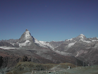
As you might expect, the view of The Matterhorn is quite dominant around the upper Mattertaal valley.
It is possible to get the train up to Gornergratt and at over 11,000ft I would recommend it. We have walked the 5,000 feet up from Zermatt, but if you take the train up you will still have some energy left to explore the high mountain region of Gornergratt and enjoy the views of the surrounding mountains and glaciers.
This view is taken from the station at Gornergratt! Monta Rosa, the highest mountain in Italy and Liskam to the right of the glacier.
The twin peaks of Castor and Pollux.
The highest point on this photo is of The Briethorn, the small dark triangle to it's right is the Kliene Matterhorn. There is a cablecar all the way up to this point 12,740 ft, it is the highest place in Europe that can be reached by cablecar.
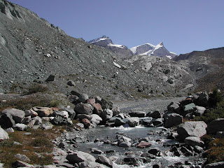
I still don't quite understand how a pond like this can exist on a glacier without freezing.
A view of the Riffelhorn, nearest on the right with the Matterhorn behind. The Riffelhorn is often used as a 'trying ground' for would be Matterhorn ascenteurs.
Riffelsee sits just below the Gornergratt Station. On a good day, the reflections of the Matterhorn are irresistible.
There are good footpaths from here all the way back down to Zermatt.
Just below Riffelsee there is a good sized herd of Ibex. If you are lucky and keep your eyes peeled, you may see them. On one occasion in September, we were lucky enough to see the males rutting. Their horns made quite a noise as they battled for supremacy over the herd.
The walk back down to Zermatt. Glad we came up on the train, it looks a long way down!
Another good day out from Zermatt is to take the cablecar up to Schwarzee, seen in the picture above. Another location that, in the right weather conditions, is absolutely irresistible to photographers. The chapel by this high mountain lake, with the Obergabelhorn as a backdrop, well it doesn't need any explanation, just look at the picture!
If you take the path up from the lake it is possible to walk up to the Hornli Hut. This is where climbers who are hoping to ascend the summit of the Matterhorn will spend the night, ready for the early start that is necessary to reach the summit. They will normally set off in the darkness at around 4 a.m and climbing up the Hornli ridge, reach the summit around lunchtime.
It feels like the Matterhorn is very close from up here. It's a good place to get a close up view of the mountain. A place to contemplate the Hornli Ridge and say to yourself "Mmm, maybe not".
Our descent back to Zermatt heads towards the Zmutt glacier. The extent to which the glacier has shrunk is very clear from here.
This path offers good views of the north face of the Matterhorn and the Hornli Ridge which is the division between sunlight and shade on the mountain.
The approach to Zermatt passes through the small mountain village of Zmutt.
In September the fields around Zmutt are full of Autumn Crocuses.
And back into Zermatt, with it's busy streets, hotels and restaurants. This is the floraly decorated Hotel Julen.
The next day out is a walk up to Stellisee...
The route up to Stellisee starts with an underground funicular railway up to the Sunegga plateau and this is the view you are greeted with as you step out, blinking, into the bright sunlight. From here it is possible to take a cablecar up to Blauherd and then the walk to Stellikee is just a fairly short contour path around the mountainside. Our preference is to make the one hour walk from Sunegga up to Stellisee and enjoy the views and the wildflowers along the way.
The rocky path makes it's way around the mountain, the Matterhorn never far from sight.
And around the corner, a seat with a view and what a view!
From August on you are likely to see Edelweiss along this section of path so keep an eye open for them.
Stellisee, another photographer's paradise.
The path down passes through an area where a glacier has recently retreated from.
And through the small hamlet of traditional houses at Findeln.
There is always somewhere with a beautiful view where you can stop for lunch.
Trift Hotel and the Hohnweg.
There is a path that leaves Zermatt to the east that is very a very steep ascent, not difficult, or exposed, just very steep and winding. At first it goes through some alpine meadows with lots of interesting flowers, before entering a wood and continuing up to the Edelweiss Hotel. The Edelweiss sits on a rocky promontory high above the town, with wonderful views all around. It makes for a good stopping off point for some refreshment.
From The Edelweiss the path enters a hanging valley, the Trift valley where the incline it now not quite so steep.
Heading up through the meadows out of Zermatt, towards the Edelweiss Hotel.
From the Edelweiss the path heads up the Trift an even higher mountain lodge, the Trift Hotel.
In the spring the sides of the path are full of alpine flowers.
From the Trift Hotel the path swings around to the left and climbs up to a high shelf. The Trift must be about the only place around here where the Matterhorn is not in view, not yet anyway. This picture is taken 45 minutes after leaving the Trift, looking back, down towards the Trift Hotel.
Eventually the path levels out with views right across the valley. The small looking dark peak near the centre of the picture is the Riffelhorn with Gornergratt and the Riffelalp to the left of it.
The Matterhorn now comes into view and the Dent D'Heren (seen here) just behind it. You can see here again how far the Zmutt glacier has retreated.
Great views of the north face of the Matterhorn where there are regular icefalls and avalanches that can be observed from here. The path here continues along the shelf high above the valley below.
After whet begins to feel like ages, we start to get a view of the valley we must defend into, knowing that there is still another seven miles back to Zermatt once we get down there!
The descent begins.
Some incredible examples of glaciated bedrock alongside the path.
As we get back towards civilisation the meadows have some lovely examples of Valaisian barns. The barns are supported on stable stones as you can see in the picture. Some accounts say it is so the avalanches can go straight under them, others say it is so that they can easily be knocked of the stones in an avalanche. This would save them from being demolished, but I wouldn't like to drag one back up the hill!


No comments:
Post a Comment