Tuesday 30 August 2016

Bank Holiday Monday

Where to go to avoid the Bank Holiday crowds? That was the question that influenced where we would walk today. Certainly anywhere near the Old Man was out of the question, there would undoubtedly be a long stream of people heading that way today. However, a walk up the other side (north side) of the coppermines valley, would still be as quiet as it always was. So we walked out of the village, through Dixon Ground, over the Miner's Bridge and out into the grand reveal which is the hanging valley of the coppermines. Where the road levels out we took the track up to the right, behind the miner's cottages and towards Wetherlam.


The path rises steeply behind the cottages and all the while there is thissplendid view of the valley and The Old Man. I have taken this photograph many times, but who could argue that one more would be too many. It is just an irresistable view!


The old mine workings are everywhere, indeed Wainwright referred to Wetherlam as "the hollow mountain". The tips and what remains of the mines and buildings are a part of the landscape. They don't detract from the natural beaut of the surroundings, rather they add interest and intrigue, as I climb up the mountains I cannot help but wonder about the lives and living conditions of my ancestors that worked here.


This feature in the landscape can also be seen in the previous picture. It is of a mine known as Simon's Nick and local legend says that Simon was out prospecting around Levers Water one day when he discovered a rich vein of copper. Delighted with his discovery and the thought of riches to follow, he headed down to The Black Bull in the village for a celebratory drink. Others in the pub that night were curious to know the nature of his celebration and as he drank more he began to talk more. The legend says that he said far too much, because when he returned to his newly discovered source of wealth the next day, it had all gone. The vein had been worked out, leaving the cleft in the ridge that you can see in the photo. As with all legends there may well be some truth there, but I suspect tat there is very little accuracy.


As the copper became harder and harder to mine, or perhaps more accurately, less economical to mine, the industry turned towards slate. There was after all a ready made workforce on hand, the miner's skills being readily transferable to quarrying. The above picture shows quarries on the front of The Old Man in a very straight vertical line. There must have been a very good vein of slate there.


High above Coppermines Valley and under the shoulder of Wetherlam, the path levels out and heads towards Tilberthwaite. Known locally as The Miner's Path, it connects the two copper mining areas of Tilberthwaite and Coppermines Valley.


Yewdale beck rises here in the boggy ground of the Tilberthwaite fells. The Mountain Ash or Rowan trees are covered with their bright red berries this year.


Looking into the entrance of the Tilberthwaite mine. Not a place to venture unless you have a knowledgeable guide. The mines are increadibly dangerous places with ancient, wet and rotting timbers and floors that look solid, but are suspended on rotten timbers. There are many hidden dangers. DO NOT GO IN!


The beck gathers pace and heads down past the village of Coniston to the lake.


Irene, heading down Tilberthwaite Ghyll.


Once down to valley level there is a good path through Yewdale Woods back to the village.


We took a slight diversion from Low Yewdale to prolong our walk on this beautiful day. We walked over Guards Wood and returned to the village near the football club.


The path follows part of the Cumbria Way and goes past this interesting looking building. It is a 19th century folly, built by John Marshall, a local land owner and has been used as a dog kennel for hounds and as a barn. The National Trust have restored it to it's original state and feature several orientation boards inside.


Saturday 27 August 2016

A Grasmere Walk

We were ready for a change of scenary, so decided on a walk in the Grasmere area. Blea Rigg and Silver How were our objectives as we had never been climbed these two modest summits before. Modest in height they may be, but not in the views they deliver. Views of the Helvelyn and Fairfield ranges, down over Grasmere Rydal and Windermere to Ingleborough and down into Lancashire. To the southwest, the Coniston fells, to the west, the whole of the Langdale range.

We left the village of Grasmere behind us and walked up through the grounds of Allan Bank, once the home of William Wordsworth and also at a later time, Canon Rawnsley.


Helm Crag from the path as it leaves Allan Bank


Up onto the fell. The beautiful drystone walls throughout the Lake District are incredible constructions. Mile after mile of beautiful stonework. They can easily be overlooked (literally) but are a monument to the men who spent their working lives out on the fells, laying stone after stone. Most of them date back to the time of The Enclosure Acts of the early nineteenth century. On this wall, the former gate post appears to have been reused to cap off the wall.


As the path leads out onto the open fell there is a large group of Juniper bushes, with wonderful contorted shapes, sculpted by the weather of many years.


Looking back over the Grasmere valley towards Fairfield and Seat Sandal.


Out over Loughrigg towards Windermere. Elterwater is visible on the right hand side.


The lakes of Grasmere and Rydal.


Irene on the summit of Silver How.


The whole of Great Langdale, from Pike O'Blisco, Crinkle Crags, Bowfell and The Pikes.


Bowfell and Langdale Pikes.


And back to Grasmere for a welcome cup of coffee.


After the rain

Sometimes when the rain stops and the clouds part, a blue sky appears that is so clear it's exciting and inspiring! On days like this you just have to go for a walk. So we walked from the village, up to Tilberthwaite and over to Little Langdale, taking the higher path from High Tilberthwaite Farm. Then following the path past the tarn and Slater's Bridge to the ford and back via Moss Rigg wood.

The single track road that makes it's way up the Tilberthwaite Valley, past old mine workings and the odd sheep.


The upper part of Tilberthwaite valley, Looking across the high pastures to High Tilberthwaite Farm. In the foreground is an interesting art installation by Andy Goldsworthy.


The ground was very wet after the rain of the previous few days, but the Devilsbit Scabious likes to populate the damp areas of the fells. This one was just opening out.


Grass of Parnasus is a beautiful small white flower that also likes wet conditions. It is quite uncommon and now restricted to a few northern, upland areas.


It's not just the plants that enjoy a wet habitat, dragonflies congregate around upland ponds and boggy areas.


Upon reaching the highest point of the walk, the views down towards Langdale are truly magnificent.


Much as we would like this weather to stay with us, the whispy clouds were suggesting otherwise.


Little Langdale Tarn.


On the walk back through the woods we spotted this little beauty grazing on the ferns.
A Speckled Wood butterfly.


By late evening those clouds were gathering again, but it was lovely and still. As you can see, the level of the lake is well above normal for August, the pier is inaccessible.


August Rain!

In the Lake District we are used to it raining, it does it frequently. True, the wet days can be rather miserable, but the days in between can also be spectacular. We had a couple of those miserably wet days last weekend, when the rain was particularly bad for August, but then in some of the days that followed, the skies were so clear. It was easy to imagine that the air had been washed clean by the rain, leaving blue skies and fantastic views.


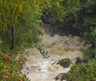
Monday morning and the becks were looking very full. This was Force Forge near Satterthwaite.


Quite a torrent!


The small streams coming off the mountains were full. This one is in Yewdale Woods and most of the time doesn't even exist. But after twelve hours of heavy rain, it looks like this.


Even the fields filled up with rainwater, but by Monday evening, the clouds were parting to show some blue sky.


School Beck that runs down through Boon Crag was full to overflowing, but again, blue sky is showing through and the promise of a good day to come.

Friday 19 August 2016

Silverdale, Area of Outstanding Natural Beauty.

Wednesday saw us taking a different tack, heading for some different terrain and some limestone country. On Tuesday night Irene discovered that a small, but quite scarce orchid called Autumn Ladies Tresses grows at Silverdale. So a little internet research and we had a definite location to head for. Silverdale is quite a special area in terms of natural history. Great areas are conserved for posterity and against changes that could threaten the environment and habitat of some very special species of birds, amphibians and plants. The RSPB looks after the huge bird reserve known as Leighton Moss, The Wildlife Trust has some unique habitat on Gaitbarrow Reserve and The National Trust manage some of the coastal areas that give home to many exciting plants, including 15 different orchids. Autumn Ladies Tresses, as the name suggests, is one of the last of our native species to flower and we had never seen one before. So we set out in the hope that today we would rectify that. It is always exciting to find a new orchid to add to our list.

It's not a very clear picture, but it's quite unusual to see Green Woodpeckers and we saw this one very early on in our walk. It was some distance away, hence the blurred nature of the photo and it seem to be very interested in this electricity pole!


Flowers attract butterflies and here we have a Brimstone Butterfly feeding on a Common Ragwort.


A Green Veined White butterfly.


A Robin. Not sure if it's a young one, or an adult just coming back into condition.


Always a comfort to see a well marked path.


Jenny Brown's point and the remains of a lime kiln.


Musk Mallow


Musk Mallow, growing at the high tide line.


Common Mallow


A lovely old, weathered, picket gate leading down to one of the coves at Jack Scout.


The National Trust sign says it all. I don't know if I am just beginning to really appreciate The National Trust, or I'm just noticing the signs more. They really have some very special places to manage, in their words 'For ever, for everyone'. For me, that small phrase really captures the importance of what they do and it is for that reason that I happily pay my subscription, so that they can continue with that work of conserving these special places, for ever and for everyone.


Autumn Ladies Tresses. This small orchid was the reason for our visit today.


More Autumn Ladies Tresses.


This was our firdst sighting of this particular little orchid and in a small area, we saw around sixty plants.