Friday, 19 August 2016

A Walk On The Quiet Side

Our walk on Monday, up to Red Dell and Pudding Stone was truly magnificent, but the return leg from The Old Man road, down into the Coppermines was unbelievably busy! There was a constant stream of people heading up the mountain in all kinds of footwear and all states of preparation. Many did not seem to be well prepared and some looked decidedly reluctant. So by contrast, on Tuesday, we decided to walk up onto Holme Fell to the north of the village. The contrast being that we didn't meet anyone. Even when the village is full of people and the area bursting with walkers, there are still walks and paths that hold that magical quality that only comes from a walk in what seems to be a deserted woodland, mountain or moor.
From the Yewdale Valley we followed the path that leads to the west of Glen Mar Tarn and onto Holme Fell, then down to the small, but beautiful tarns above Hodge Close quarry, then down to Hodge Close, Holme Ground and back to the Yewdale Valley. Solitude and sunshine all the way.

Looking towards Langdale Pikes from the top of Holme Fell.


The view towards Fairfield from Holme Fell, the heather in full bloom.


To the west towards Wetherlam.


Looking south, the view includes almost the full length of Coniston Water.


A closer view of the lake


This tarn was built to supply water for the nearby quarry at Hodge Close.

Monday, 15 August 2016

Coppermines Valley and Red Dell

Well the wam summer weather has returned. Perfect conditions for walking this morning and good to have some blue sky and sunshine to add to the photography. We set off up into the Coppermines Valley, headed around the back of Irish Row, a small terrace of houses built to house miners.The track gradually rises up to Red Dell where there are some of the oldest mines in the valley, dating back to Elisabethan times. There is also the industrial remains of a large water wheel, the wheel has long since gone but the masonry is still there. This part of the site is likely to change in the near future as lottery heritage funding has been allocated to allow for a comprehensive survey and some restoration. So I thought it would be worth recording the site as it is now.

As you enter the hanging valley, the view opens out and it feels like you really are in the heart of the mountains.A beautiful valley with the added fascination of the industrial heritage.

Irish Row, where it is said that the miners slept top to tail in the beds and the beds never went cold, because as one shift got up to go to work the previous shift came back to get into the beds.

This view is looking over to Coniston Old Man and the disused quarries clearly show the line that the slate takes up the mountainside.

The wheel support and pit at Red Dell.


Looking down the valley towards the village and the lake, from Red Dell.

Heather growing around the old mines below Kennel Crag. These mines are now fenced off to dicourage curious walkers from venturing too near. Believe it or not, people have had to be rescued from this mine after trying to jump across and not quite managing a safe landing. The fall down the shaft could result in a 1,000 feet fall.


Looking back towards the mine workings, across Red Dell Beck.


Our path then followed the old water course. A small lavada, or canal, used to channel more water to the wheel at Red Dell.


An old sluice gate on the water course. No, I'm not referring to myself!


The path / water course contours under Grey Crag where I photographed this Hawk Bit, framed by Heather. Eventually the path arrives at Paddy End, a large area that was used for processing the copper ore. There is still much evidence of past work, but now is the site for the water treatment works, feeding the village and much of the surrounding area.


From Paddy End a path leads south west up a short incline to the Pudding Stone, in Boulder Valley, pictured above. This huge boulder being about thirty feet high is roughly the size of a house!


From Pudding Stone there is a path back to the Old Man road. This patch of Hawk Bit were growing on the banks of one of the old disused quarries. The Red Dell valley can be seen in the back ground.


More Hawk Bit and recently built cairns.


Our route back to the village took us back into the Coppermines Valley where Heath Spotted Orchids are still growing late in the season.

Saturday, 13 August 2016

Where's the heatwave?

After several days of weather forecasts full of hot weather and sunshine, we in Cumbria are beginning to wonder where it is. The answer is simple. As usual, it's in the south, but it looks like we might be offered a taste of sunshine early next week. Here's hoping. So after a wet morning we managed to get out for an hour or so, a walk that is known locally as 'round Yewdale'. Out of the village on the Ambleside road, into Yewdale Woods, cutting across the Yewdale Valley at Low Yewdale, through to Boon Crag and the head of the lake, then returning to the village. There has been much cutting of the hedgerows and verges, so not many flowering plants left to photograph, but the decimation of the hedges by mechanical means has far wider implications for our wildlife than for a photographer. The impact on birds, mammals and others can be a devastating loss of food sources and habitat. Here is some of what we did see today....
I seem to be developing a strange fascination for this bridge in Yewdale Woods...
Yes I know, I've photographed it a few times this summer.
Crocosmia, growing beside the path in the wood.
Angelica, a flower that apears in the woods and along the margins of fields in late summer.
Snow berry, a shrub with a tiny flower and soft white berries.
A very small balsam flower. It looks like a smaller version of the Indian Balsam that I posted earlier in the week, but yet to be positively identified.
The same balsam flower.
These are the seed berries of an arum lily goes by many common names. Lords and Ladies, Parson in The Pulpit and Cuckoo Pint to name a few.
Sailing offshore from Tent Lodge.

Thursday, 11 August 2016

Buttermere.... But a mere drop of rain!

The forecast for Monday looked good, so the plan was to drive over to Buttermere to exploere the botanical delights of yet another of our beautiful Lakeland valleys. It's about an hour and a quarter from where we live, so we try to reserve it for days when the weather is guaranteed. Unfortunately, on this occassion it didn't quite work out like that. The weather wasn't kind and as we drove northwards it appeared to be gradually deteriorating. We parked at Buttermere and decided to walk around the lake anyway and see what photographic opportunities came up. We had planned to walk a bit further, but conditions were not inspiring, damp, grey, windy, not good. The light was too flat for decent landscape photographs, but flat light can be good for flower photographs. The one thing you don't need for flower photographs is wind and we had that too. Oh and for good measure, there was the odd shower thrown in too. Anyway, we did the walk and we tried to get the best photographs we could in the given conditions. Here they are....
Buttermere is yet another area managed by The National Trust.
A classic view of Fleetwith Pike across Buttermere, but it was not the best day to capture what can be a stunning view. Still, it was enjoyable to be there.
This is one of my favourite place to photograph Buttermere, at the point where the river leaves the lake. The view over the moss covered rocks, to the lake and onto Fleetwith Pike, with the river flowing by, can make a fabulous image. The river only flows a short distance into Crummock water, so they haven't wasted a good river name on it, instead it has the inauspicious title of Buttermere Dubbs!
Two more views as our walk progressed along the western shore... "And living on your western shore, saw summer sunsets, asked for more..."
The much photographed boathouse of Buttermere. I often wonder if it really is a boathouse. It doesn't look like one.
The sun was trying and I was trying to find a new and interesting composition. I'm not sure either of us was wholly successful.
But when I turned around, there seemed to be better light behind us, maybecoming our way?
We got a brief glimpse of the sunshine, a few seconds at a time, but as the clouds piled up against the mountains, the gaps between them disappeared.
And so it seems the sun had passed away this dark, damp day on Buttermere. But sure to say, it will be here again soon. If it could kindly coincide it's visit here with mine...... we could be friends once more and conspire to make some better images, next time.

Tuesday, 9 August 2016

Summer wild flowers on Cunswick Scar.

Where to explore next? Well after a brief discussion on the subject, Mrs Cooper fancied some different terrain, some limestone underfoot and I agreed that it would make a pleasant change and maybe a variation in the wildlife. So we set off to walk Cunswick Scar near Kendal. We parked at the bottom of the tramway on Queens Road in Kendal, the tramway had been an old link of about quarter a mile, to a limestone quarry on the fell just above the town. Nowadays the tramway is a paved lane that leads to footpaths across Kendal golf course. This had been a very regular route for us when we lived in Kendal. At one time we lived on Serpentine rd and did the walk most nights after work. So it was interesting to see some different terrain, whilst at the same time, visiting an old familiar route. Familiar that is until we got onto the golf course, where a wall that the path used to follow had gone and the route not as clear as we remembered it. The path from the end of the tramway up to the fairways was covered in all kinds of wild flowers, the dominant species must have been the scabious, looking beautiful in their full, summer bloom.
Scabious covering the grassy hillsides around Kendal golf course.
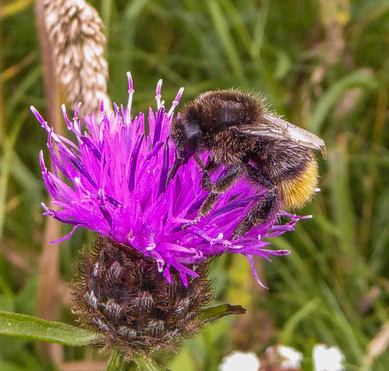
The bees were making the most of the summer.
Kidney Vetch, another summer flower that prefers limestone meadows and heaths.
Agrimony, adding to the patchwork of colour along the footpath.
Bettony, seems to occur in a variety of locations. It appears to be as happy here on well drained limestone as it is in the damp areas around the lakes.
Potentilla, a small geum that gaws all over the limestone heaths. So taking our chances, we crossed the golf course without incident, looking for the stile in the wall on the other side of the fairway. Things didn't quite look the same, but then we spotted a gate in a corner where two walls met. furthe on again, another gate, all of the stiles appear to have been replaced by gates. Easier access I gueass, but a slight change in the character of the walk. I'm happy with gates if it means the walk is accessible to more people. Across another field and the path crosses the A591 via a specially constructed bridge.I'm very glad they put the bridge there when they built the Kendal by-pass, I wouldn't fancy trying to cross the main road into the lakes from the south! Across another field and out onto the open scar, with a cairn at it's highest point. The 360 degree views were a bit hazy today with the appearance of showers in the distance. But we could see the fells of Coniston, Langdale, Ambleside, Kentmere and out to Long Sleddale. We could see the Howgills, Benson Knott and down the lower Kent Valley.
Looking south from Cunswick Scar, back across the golf course.
Always good to see a variety of butterflies. This one is a Painted Lady.
Small Copper
I'm not totally sure about this one, maybe a very faded Meadow Brown?
Eyebright, a tiny little flower which is actually a prasitic plant, growing everywhere up on the scar.
Hare Bell, another prolific flower at the moment that seems to thrive in a variety of conditions.
Scattered across the scar is the eye catching yellow of the Hawkbit, seen here growing against a limestone wall. The path follows the line of the escarpment almost to the point where it meets Scout Scar, where there is a cross roads in the footpaths and we took the one down towards Bradley Field. The path heads down through thick gorse bushes where we remembered seeing lots of rabbits bouncing around infront of us, usually around thirty every evening. Today the path was quiet, no sogn of the burrow at all. Rabbits appear to be in decline yet again, but with their capacity to make a come back I'm sure it won't be long before they are a common sight again. At Bradley Field the path joins the Underbarrow road which took us back into Kendal, but still plenty to see here. The roadsides had yet more wild flowers to show, with field geraniums, teasels and giant bellflowers to name the most noteable ones.
Field Geranium
Teasel
The Giant Bellflower which can grow to a height of five feet. Definitely a plant that loves limestone.
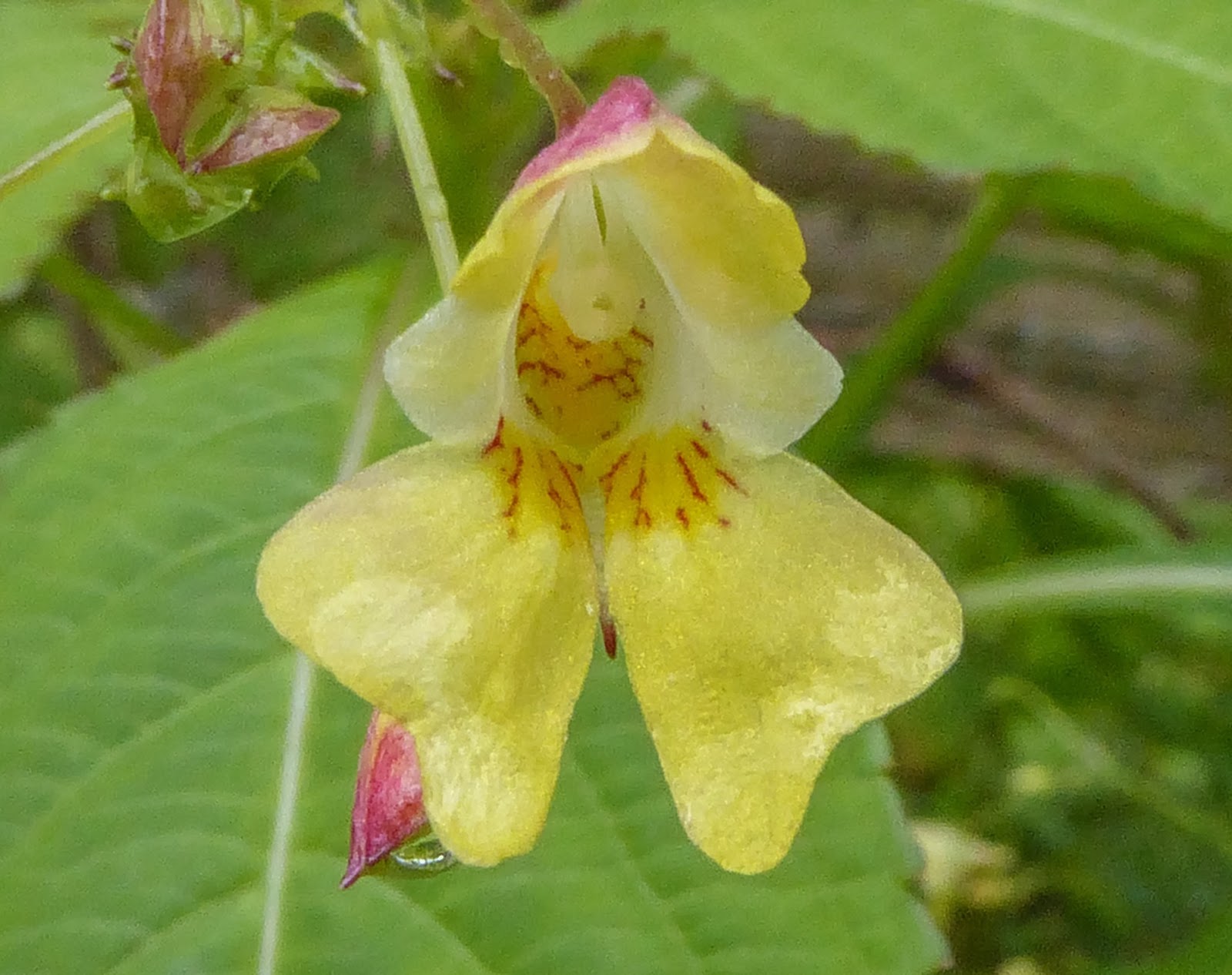
And as we approached the outskirts of the town, we stopped to have a look at the old, restored lime kilns. Here we photographed Indian Balsam. As the name suggests, it was imported from the Indian sub continent into parks and gardens. In recent years it has become something of a problem in the wild as it colonises and dominates where native plants once grew and in some areas steps are taken to control it. All the same, it is a beautiful flower. A very enjoyable hour and a half, walking the limestone escarpment to the north west of Kendal, photographing some of it's many wild flowers and butterflies.